

The lakers and salties have returned to the Seaway shipping lanes. The sunsets over the Canadian shore remain picturesque orbs of gold set in orange and violet horizons. Soon we’ll be able to pull out a deck chair and enjoy warm, gentle breezes during peaceful spring and summer evenings on the St. Lawrence River. Perhaps a few crickets. Maybe some lights beaming from the opposite shore. Definitely the stars above.
That’s the river life we treasure. It holds all the tranquility and contentment of playing with a newborn grandchild. Coincidentally, the river represents an infant in geologic time.
We couldn’t sit on our lawns and decks 10,000 years ago, not because of our life expectancy, but because the river was still taking shape.
The St. Lawrence River Valley rests in a depression between the Appalachian Mountains and the Canadian Shield, the landmass north of the river that occupies the eastern half of Canada. To understand the life of the St. Lawrence, humor me with a geology lesson that unapologetically clashes with the Bible.
Per Christianity, mankind has occupied Earth for about 5,000 years since Eve was formed from Adam’s rib. However, Asians walked across ice to the North American mainland somewhere between 16,000-20,000 years go. Scientists will tell you the Earth is more than 4.5 billion years old.
To put our beloved river in perspective, the best starting point would be about 300 million years ago in the Pennsylvanian period. What is now the eastern seaboard of North America was still joined to the coast of Africa. It needed about 240 million years of shifting among the Earth’s tectonic plates for North America to assume its position in the North Atlantic Ocean. It’s roughly the same era that dinosaurs became extinct.
Now fast forward to the last glacier, the Laurentide Ice Sheet, which began to form about 75,000 years ago and grew to 2½ miles thick. About 21,000 years ago, the glacier extended over New York and New England, most of Pennsylvania and Ohio, and all of the Great Lakes. As temperatures rose and ice melted, the glacier began to retreat into Canada and the Great Lakes reemerged. Glacial lakes formed along the edges of the ice sheet. During one era, the waters of Lake Erie drained eastward across central New York and down the Hudson River valley.
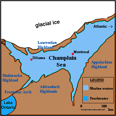
Ottawa-Carleton Geoscience Centre
As the ice continued to melt and recede northward, Lake Ontario and northern New York reemerged from their frozen blanket. The weight of glacial ice had formed a depression in the Earth’s crust. Melting ice formed a massive body of water across southern Ontario and northern New York about 13,000 years ago called the Champlain Sea. It took about 3,000 years for that depression to drain into the Atlantic Ocean, leaving us the Thousand Islands and path of the St. Lawrence.
With the ice gone and plant life expanding, nomadic hunters and gatherers migrated northward, emerging after thousands of years as the Haudenosaunee (Iroquois) and Algonquian-speaking nations. By 1534, Jacques Cartier reached the Gaspe Peninsula and claimed the land for France, Because it was the feast day (Aug. 10) of St. Lawrence, Cartier named the river. Within a year he visited Native American villages at Stadacona (Quebec) and Hochelaga (Montreal). That paved the way for Samuel de Champlain to establish the first permanent European settlement at Quebec city in 1608, then Sulpician missionary Francois Picquet built Fort de La Presentation where the Oswegatchie and St. Lawrence rivers meet at Ogdensburg in 1749.
The river wasn’t the only benefit remaining from the Laurentide Ice Sheet. The weight of its ice left depressions aligned in a southwest to northeast direction, from Theresa to Depeyster. We know these Champlain Sea remnants as:
- Hyde Lake
- Clear Lake
- Crystal Lake
- Mud Lake
- Butterfield Lake
- Grass Lake
- Lake of the Woods
- Black Lake
Riverside life has given us a lifetime of memories. Being pulled out of the water by my hair and then a limb by my father. Working on the Nepco oil spill of 1976, the most lucrative summer job ever. Listening on a warm summer night as the tunes of Barenaked Ladies drifted from Brockville across the still water.
I’m looking forward to warmer temperatures and blazing sunsets.
Morristown native Jim Holleran is a retired teacher and sports editor from Rochester. Reach him at jimholleran29@gmail.com or view past columns under “Reflections of River Rat’’ at https://hollerangetsitwrite.com/blog/

Who would have thunk it?Sent from my iPad
LikeLike
This is great! It’s why I get that “I need a river fix” every year in April. I want/need to go HOME! Once you get some SLR in your system you get that urge every spring; no matter how far you go, you HAVE to go home to the river.
LikeLike